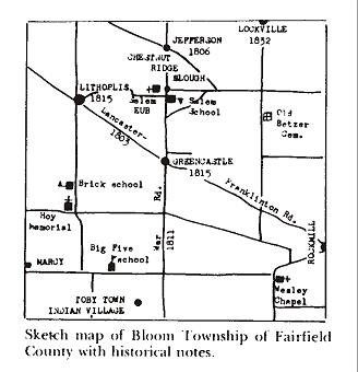
Bloom Township was organized in 1805 and appears in the Fairfield County tax assessment book of 1806 as Township 14, Range 20. It is bordered by Franklin County on the west, Violet Township to the north, Greenfield Township to the east, and Amanda Township to the south.
Origins of the township
When the Board of Commissioners laid out a number of county townships during the November 1805 term of the Court of Common Pleas, Bloom Township was much larger than today’s roughly 36 square miles — it originally included all of present-day Violet Township as well. The first township election was held at the home of Abraham Van Courtright.
Why the township carries the name “Bloom” isn’t recorded in the county histories. One often-repeated guess connects it to the witch-hazel that would have been blooming in the Rockmill gorge — where a mill was erected in 1799 — at the time the township was created.
Springs, streams & the first roads
Although no early roads reached the area before 1802 and no navigable streams crossed it, Bloom was settled early in the county’s history. An abundance of strong-flowing springs likely drew the first settlers. The most famous were at Jefferson, whose waters were bottled and sold in Columbus as “Jefferson Spring Water” — much in demand during a typhoid scare that hit central Ohio around the turn of the century.
Among the first roads laid out in what is now Fairfield County was the New Lancaster–Franklinton Road, opened to Rockmill in 1802 and extended through Bloom Township in 1803. The first north–south route, the Wheeling-to-the-Lakes “War Road,” was established in 1811 and passed through Greencastle (laid out 1815) and Jefferson (established 1806).
Rock Mill: a mute reminder of the past
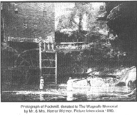
New Englanders Joseph Loveland and Hezekiah Smith erected the first mill at Rock Mill in 1799 — a log grist mill on the upper falls of the Hocking River, said to be the first built on the river. Handy to travelers, the mill became a resting place, a general supply stop, and a bartering spot.
A later mill built in the basin below the falls was washed out by a flood and rebuilt in 1824, powered by an overshot wheel 26 feet in diameter. The building was remodeled in 1899 to replace the aging water wheel with a turbine, later converted to steam. W. S. Alspach was the last milling owner; the mill stopped operating in 1905. It is now owned by Fairfield County Historical Parks, which has spearheaded its restoration.
The country schools of Bloom Township
Religion and education mattered to the first settlers. Abraham Courtright was teaching school in the township as early as 1805. Over the following decades, a network of one-room schools — Districts 1 through 12 — served the township’s scattered communities.
Many of these small brick and frame buildings still stand, most converted into attractive homes. Among them were the Chaney School (No. 1), the Lockville school (No. 2, later Zion Lutheran Church), the Coonpath School (No. 7), Wesley Chapel (No. 8), the Salem School (No. 10), and the Moore School (No. 12). The Jefferson School (No. 3) long stood abandoned — a reminder of how easily this history can be lost.
The pioneers & their land patents
Nearly 100 land patents were issued by the General Land Office for lands within Bloom Township, most in the early 1800s. The first went to David Wright in 1802, on a patent signed by President Thomas Jefferson. The patent for Section 25 — where Rock Mill sits — was signed by President Andrew Jackson in 1837 and issued to Joseph Buchwalter.
The greatest number of government land sales took place between 1811 and 1815. The township’s early communities were laid out by these settlers: Jefferson by George Hosher in 1806, Greencastle by Jesse D. Courtright in 1815, and Centerville — now Lithopolis — by Frederick Baugher.
Lithopolis Road — the first road in these parts
In 1803 a road was built from the public square in Franklinton (which became Columbus) to Lancaster, linking the new settlement to Zane’s Trace. Part of that route — from near Groveport to Lancaster — is today’s Lithopolis Road, making it one of the first roads cut through this part of the Ohio wilderness.
Lithopolis itself was first named Centerville because it sat roughly halfway between Lancaster and Columbus. In 1836 a local doctor suggested the name Lithopolis — Greek for “village of stone” — for the large sandstone quarry then in town. The ravine running the length of the village is the old quarry.
Sources
This account draws on published local histories, principally Crossroads and Fence Corners by Charles Goslin (1976), with additional material from the Lancaster Eagle-Gazette (“Rock Mill Is Mute Reminder of Past,” Katrina Predmore, June 25, 1991) and the Columbus Dispatch (John Switzer, May 18, 1995). The historic Rock Mill photograph is courtesy of Len Hajost.